
Editorial and news
Instrument Corner
Easy Suunto lighting technique
Tests on deviations caused by various magnetic objects
A review of the new 'Twin' combined compass/clino.
Magnetic Field Variations -Vic Schmidt.
Some words from an expert on the possible errors caused by fluctuations in the earth's magnetic field.
HTO survey data interchange format -Doug Dotson/Wookey
Hierarchical Tagged Objects - A proposed survey data description language for the interchange and archiving of survey data.
Compass Points is published Quarterly in March, June, September & December and is edited by Wookey.
It is a sister publication to the Newsletter and Journal of the Cave Radio & Electronics Group (CREG), a special interest group of the British Cave Research Association (BCRA).
You can obtain a copy by joining the CREG. Send £2.50 (or £1.60 if you are a BCRA member), to David Gibson, 12 Well House Drive, LEEDS, LS8 4BX. Tel: 0532 481218.
Text (and possibly postscript) copies will soon also be obtainable by anonymous ftp from the Cavers Archive: gserv1.dl.ac.uk. Files are CPointnn.TXT or CPointnn.PS in the directory /pub/caving/CPoints, where nn is the issue number.
Send all correspondence and submissions to:-
The Editor, Compass Points,
28 Spalding Way,
Cambridge,
CB1 4NR.
Tel: 0223 243215 (Home),
0223 811679 (Work- 12 till 6),
E-Mail: Wookey@aleph1.co.uk.
Articles can be on paper, but the preferred format is ASCII text files with paragraph breaks, but if they are particularly technical (i.e. lots of sums) then Microsoft Word documents are probably best, WordPerfect docs are also OK. Floppies can be either size, any DOS format, although RISCOS floppies (or Mac, Atari or Amiga at a pinch) will also do. Even PCW 3" discs are feasible - but don't send them the day before the deadline! For these we can deal with text or Impression (Archimedes) or Microsoft Word (Mac) docs.
Future articles in the pipeline:
Part 2 of Wookey's Compass Calibration data analysis based on 4 years of CUCC expedition data.
Details of a source of magnetic field data to allow you to orient your surveys with confidence.
A discussion of complex subject of error treatment in survey software.
Survey Draughting using !Draw - The pros and cons of using standard vector graphics packages to produce the final printed version of a survey.
A list of currently available survey software, prices, platforms, where to get them from, and short summaries of their capabilities.
Hello again. The response to issue 1 of Compass Points was encouraging with a number of comments along the lines of 'Good idea, keep it up', and a number of letters on various subjects. The only thing I haven't received yet is any articles, so this issue is composed from your letters and some things from the Cavers' Forum. To be interesting this publication needs diverse input, so if you don't like what you read here don't blame me.
Here are some things that might be of interest to give you some ideas:
Current survey projects underway in the UK or abroad - the impetus behind them, the purpose, the techniques used, the people involved.
Expedition versus home survey techniques - clipboard surveying, topofil, instrumentation, recording, data processing, map production.
Discussion of the validity and relevance of survey gradings.
Map production techniques - from survey book to publication.
As of now we have a couple more sections: Surveying Tips, where we can spread the word on those little techniques that make all the difference between easy and difficulty, success and failure; and Questions & Answers, where you put those questions that have been bugging you for years, and hopefully someone will supply the answers.
To reduce the chance of instruments fogging up keep them in a sealed container along with some carbide between trips (or even during trips). This will keep them desiccated, and stop moisture accumulating.
Is it possible to obtain Sisteco instruments in the UK, and if so where? What is their country of origin?
Sometime next year, probably just after the next issue of Compass Points there will be a surveying Field Meet/Workshop. It is not very organised yet but we would like to give people a chance to use the various survey programs available, discuss issues such as data standards, and to do practical experiments. It will be an informal event run much like the CREG's field meets, where anyone who has anything to say/show/ask can do so. Will those who fancy coming to such an event give my answer-phone a ring to say so, and if anyone has any particular ideas about where and when make them known soon. If no-one speaks out it will probably be at the South Wales CC cottage in April.
Plans are also afoot for a proper BCRA symposium around Easter 1995. Please register any interest / ideas with me or Pete Cousins.
The BCRA currently awards the Arthur Butcher Survey Award at the National Conference every year. It is awarded by a panel of three judges picked by BCRA Council for any contribution to cave surveying considered worthy.
The recipients over the 6 years for which it has been operating are:
1988: Dave Ramsay and Arthur Millett for the Llangattwg cave survey
1989: University of Leeds Speleological Society for effort put into cave surveying.
1990: Colin Boothroyd on behalf of the Mulu expeditions for the Clearwater/Blackrock cave map
1991: Dave Irwin for perseverance with the St Cuthbert's Swallet survey
1992: Cambridge University Caving Club for contributions to the theory and practice of cave surveying
1993: Juan Corrin for continued service to cave surveying.
It seems to me that whilst this award is appreciated by its recipients it does not have a high enough profile at the conference. I would like to see a proper salon, similar to the photo salon, for cave surveys. With the panel judging the best survey, and more importantly display and criticism of the better surveys at the closing ceremony. This should help to improve overall standards and show people what is achieved by dedicated surveyors slaving over hot sheets of A0.
It might perhaps be best to have a separate award for best survey, with the Arthur Butcher award itself being awarded in the current non-specific way. What do you think?
Survex version 0.32c is now available. This gives a number of improvements over version 0.30 described in Compass Points issue 1.
300dpi printing from DOS
Canon BJ printer driver
Faster processing of caves in less memory (using Choelski factorization)
More helpful, and completely internationalizable error/warning messages
Options for printing station names, crosses, and the border
International Characters permitted using TeX representations
Survex from/to HTO conversion utility provided
Friendlier expiry, so you won't be left with a program
that refuses to run.
I was pleased to see your article in 'Compass Points' on Calibration, and in particular to see the common fiction that Clinos have no zero error rebutted. Everyone that I know who has tried to compile the work of several surveyors into a composite plan has found that lack of calibration / mistaken calibration / rare magnetic events have caused passages to move further than random errors could permit.
I attach copies of Magnetic and Solar Activity, and also the RGS brochure to which I referred in my published letter. The former were sent to me by T.J Harris of the Geomagnetism Group in 1991, and were circulated to a number of interested cavers at the time. Unfortunately, I have failed to make contact with the group since to explore better ways of presenting the data. There is also a 'Centre for Terrestrial Physics' at the Rutherford Appleton Laboratory, Didcot, Oxford.
As I commented to Patrick Warren a few years ago, there is a danger in applying least squares reduction to raw cave survey data, in that a high proportion of the closure errors may not be random. (i.e. they are inherently calibration dependent). I suggest a two-phase closure in which the major passage segments from individual survey trips are first 'swung' to give a best fit, and the residual errors only are then re-distributed in a second pass. This avoids moving perfectly sound passage because someone had a hangover when he/she was supposed to be calibrating the compass. There will of course always be an 'uncertainty' of at least half a degree over any calibration. The agreement we now have between the composite Llangattwg Survey(s) and Stuart France's Cave to Cave Radio Location has only been achieved after offending passages on both sides of the potential 'connection' were swung through about a degree. There are unfortunately three churches in the Usk valley visible from Llangattwg...!
I am trying to get BCRA to revive the regular one-day thematic spring symposia that were a feature of the 1970's and 1980's. Both Bryan Ellis & I think there would be a lot of interest in a combined Radio Location / Surveying theme. What do you think??
P.R.Cousins, Lichfield
[I agree entirely - see above. Pieces relevant to both your Geomagnetic info, and survey error ideas wouldn't fit it this issue but should be in the next one]
...Enclosed are a couple of pages from my maths book listing the pros and cons of various computer methods of solving simultaneous equations and showing the principle of the Gauss Siedel method which is used in SURVEY [This has since been updated to use a variation called Successive OverRelaxation, which achieves more accurate results and is faster]. It clearly implies that iterative methods should be used for large numbers of equations, but I would be interested in any comments on the subject.
Also enclosed is a copy of Dave Irwin's [and Stenner's] paper on assessing the accuracy of cave surveys. SURVEY uses his criteria to judge the acceptability of each closed traverse, but I am not really happy with this as I think his definition of a standard deviation is too lenient by a factor of two - do you agree? There is also a big question mark in my mind about whether the BCRA grades are for 1 standard deviation as stated in Dave's paper or for 3 standard deviations as implied by Bryan Ellis's book (which Bryan says was based on the paper in the first place!). I think a discussion of these matters in Compass Points might be worthwhile.
Steve Neads, Radstock, Bath
Daniel H Gebauer,
Schwäbisch Gmund, Germany
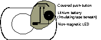
Concerning Suunto-lighting some ten years ago I had a frustrating experience when drilling into the aluminium body: I accidentally hit the liquid filled capsule and killed the Suunto.
The illustrated method of mounting the soldered LED, battery, and button with the help of silicon-type elastic requires no work-shop, no drill, not even a drilling machine. Don't forget to cover the button before gluing everything together.
The last arrangement I made this way worked for four years on several expeditions in cold, wet, hot and dry caves of Austria, China, Madagascar, Usbekisthan & Nepal.
Greg Springer/Wookey
It is possible to get your Suuntos refurbished at very reasonable cost by suppliers in the States. For $48.99 including shipping (about £30) you can have your Suunto thoroughly fettled, including getting the compass sealed unit replaced if necessary. After this treatment it should be as good as new, and given the cost of new Suuntos (just about £250 for an illuminated Compass/Clino pair, and £215 for plain ones), this seems like a good deal, even allowing for an extra few quid to ship them to America and back.
If anyone knows of any UK/European outfits who can provide similar services please let us know.
The address is :
Forestry Suppliers Inc.
205 West Rankin Street
Jackson MS 39284-8397
Phone: (601) 354-3565
Telex: 585 330 Forsup inc jks
As many of us have likely learnt through painful experience you need to be very careful what metal objects you place near to your compass when taking readings. I have been on trips where data has been ruined by alkaline batteries in Zooms, and metal rims on helmets. Here are the results of some tests done by our American friends.
Tom Moss
I wonder how many other cavers have put a compass on a tripod, (no use for surveying if it is magnetic), sighted a distant object, and then moved familiar items like wrist watches, climbing gear, spectacles and lights past the compass to find the closest approach distance that causes no deflection? This experiment can be quite educational!
These are the results of some tests we did as an exercise during an FCP (Fern Cave Project) instrument class last year. The values represent a "safe" distance where the item could not be seen to have any effect upon the compass. The tests were done with a tripod-mounted Brunton.
By the way, magnetic screws in your glasses needn't be a problem. Just take a 'gross' reading with the Suunto close to your eyes, then bring it out 4 or 5 inches to read the fraction of a degree. Your reading will be more accurate that way anyway. For many headlamps/hardhats with a low radius of magnetic attraction, it may suffice to push the hardhat back on your head and use this technique.
Object Distance in inches
Petzl Ecrin hardhat 0
MSA comfo-cap hardhat 0
Plastic & metal lamp bracket 0
Mini-mag without batteries 0
Roosa-Lite headset 1
Wire-rim glasses (screws) 1
Mini-mag with 2 AA nicads 3
Carbide lamp striker unit 5
Lost Creek pack steel strap clip 5
2 AA nicad batteries 5
Panasonic 4-AA headlamp 5
Petzl Mega 6
Night-lite headset 6
One alkaline D-cell 6
Stubai pear-shaped steel carabiner 7
Small wooden-handled hammer 8
Joe Brown with 2 lamp brackets 8
Justrite Electric headset 8
4" dia. steel carbide lamp reflector 11
Metal Justrite battery pack 12
Small Tekna knife (magnetized) 15
Brunton compass 15
Suunto (metal) compass 18
Kevin Harris, Boston Grotto
I ordered and tried "the Twin", a new compass/clino combination from Suunto.
It is on sale through Oct. 9th from Forestry Suppliers, Inc. It differs from the individual compass and clino significantly. In particular, rather than extending the case in both directions to accommodate the eyepieces, it has two top mounted "turrets" with built-in mirrors and lenses. This means you actually read the top, rather than the side, of the compass and clino cards.
The degree marks are perceptibly radial, rather than all being parallel to the reticle. The marks close to the reticle are nearly parallel to it, however. Only full degrees are marked on the compass, rather than 1/2 degree on the regular compass. You can still estimate to the nearest 1/10 degree, however, because the lens is larger than a standard Suunto compass lens. It allows you to see clearly from farther away, even 12" presented no problems. Because of the top mounting, and the thin top shell of the turret, it is much easier to line up the reticle with an uphill target than with an ordinary Suunto compass. The biggest problems with the Twin were:
a) Because you view the top of the compass card, there is no way to tell when the unit is level. You can only tell if it sticks by turning it. I haven't yet done any experiments to see how much error is introduced by off-level reading, so perhaps this isn't really a problem.
b) Because of the turrets, the Twin is approximately twice the thickness of an ordinary Suunto compass in two spots. This probably doesn't matter much in your pack, but when moving through a tight squeeze, it means you can't keep them in your breast pockets like you can with the compass and clino.
c) The turrets are strong hard plastic, but are considerably less robust than the aluminium housing of the main unit. Also, the top of the turrets have cross hatched grooves on the outer surface to serve as a light diffuser. These grooves attract mud instantly.
d) Because you must sight over the top of the housing to line up the compass, it is impossible to use the unit when the target is at negative elevations (i.e. below the horizon). Small negative elevations (up to -10 degrees) might be possible if the unit is accurate when used that way.
Considering all the factors, I think separate compass and clino units are still preferable in North-eastern US cave surveying. The Twin would be preferable for some survey conditions, when passages are fairly level and crawling is unnecessary.
Vic Schmidt, Dept. of Geology & Planetary Science, University of Pittsburgh
Here is a brief run-down on the question of short-term variations in Earth's magnetic field. I'm a geophysicist with a speciality in paleomagnetism, so geomagnetism is at least something I have studied and taught classes in.
Daily and monthly variations due to solar and lunar tides in the magnetosphere and changes in sunlight heating of the ionosphere (and other effects) are pretty minor, usually amounting to around 20 nT (nanoTesla), while the total Earth's field at temperate latitudes is on the order of 50,000 nT. During solar flares and other things that can induce magnetic storms, the field can become much more disrupted, with sudden commencements of storms generating variations typically up to around 100 nT lasting from a few minutes to a few hours. This is highly dependent on latitude -- in auroral regions, the amplitude can go over 1000 nT, but more than a couple hundred nT is rare in temperate zones.
(Does that exclude Great Britain? The last time I was there in the summer I nearly froze to death! -- No, seriously, even at N 55 degrees, effects tend to be moderate). The K index is used as a worldwide standard of magnetic activity, and it tops out at about 1000 nT, based on the interval 6:00 - 9:00 UT Apr. 16, 1938, the most active on record.
So let's take a worst-case scenario of a 1000 nT disturbance affecting the horizontal component of the field (around 17,500 nT in northern England just now) with the disturbance field at right angles to the main field. The deviation angle would be slightly over 3 degrees for a few hours. A more normal magnetic storm of a couple hundred nT would provide a deviation of around 0.6 degree or less for a few minutes to a couple of hours. Daily variations of around 20 nT contribute less than 0.1 degree error.
I maintain that anyone who claims to be able to attain accuracy to better than 0.6 degree in a magnetic survey is deluding themselves.
As I pointed out a while back, failure to keep track of the long-term secular variation in Earth's field can easily throw you off by much more, with it amounting to up to 0.2 degree per year in many places.
And it is strictly cumulative, so if you use 10-year-old map data, you can easily be off by a full degree (all the time!).
Believe me, it is hard to attain accuracies of better than one degree with Brunton or Suunto compasses.
So my advice is, you have far more important sources of error to worry about than magnetic storms -- like local variations due to nearby magnetic minerals, which can throw off your readings by several degrees, even in limestone zones.
[Unfortunately Vic died a couple of days after writing this]
As many of you are aware work on a survey data standard has been going on for a couple of years now. I was galvanised into action by Stuart France's original treatise on the subject and have since had numerous discussions on the subject with those interested. I found that Doug Dotson, aka Speleotechnologies, the producer of SMAPS, was also very interested in this subject, having already produced SEF (either SMAPS Exchange Format, or Standard Exchange Format, depending who you ask!) during 1991. This was a somewhat idiosyncratic exchange standard with a rather SMAPS-esque feeling about it, possibly contributing to its less-than-dramatic take-up. However it was a start, and served as a basis for discussion - illustrating a number of problems with that approach to the problem.
Doug has since done a lot more work, taking into account the comments of many people, and come up with HTO (Hierarchical Tagged Objects). This is a very boring name for something which is itself also very dull, but has the potential to be a very significant and useful development. The standard uses tags to identify data items, and scoping to give object-style inheritance of data items (such as 'Survey Date') that apply to sections of data.
The standard is still in Draft form (version 1.1, September 15th 1993) and comments on it are very welcome. Unfortunately, the standard itself is too long (21 pages) for this publication, so I will just give this summary and Doug's introductory comments, and examples.
If you are interested in the subject, or use of the standard, then you can obtain a copy of the HTO distribution from me or the Cavers Archive (UK). The distribution contains The HTO spec (in Microsoft Word 2.0, WordPerfect 5.n, Postscript, and ASCII Text formats), the access library functions (in C), DOS executables, and some example data. If you would prefer a paper copy of the spec, please send a cheque for £1.50 to cover photocopying and postage.
At the moment the only survey programs which support HTO are SMAPS (obviously), and Survex (with a fairly primitive separate conversion utility). After studying what is required in a survey data exchange standard for some time, and examining HTO thoroughly, I believe that it will do a good job of data transfer and archiving, and therefore deserves support. If you have written survey software and would like to be able to import, export, and archive data easily then I think you should look at HTO seriously and consider implementing it. Much of the hard work is done for you by the library functions, but obviously only you can write the code to use those functions to output/convert from your data format.
The standard contains several important concepts.
HTO is designed to be extensible. Adding facilities which are not currently catered for will not invalidate old data. Equally programs can store any data for which there is not a standard tag in an HTO file, and read it back in. Other programs which do not understand such items will just ignore them, preferably generating a warning in case the data is important.
Original units and data formatting are not lost, even though they may be stored in a different format internally in the HTO file. The formatting and unit data can also be kept in the HTO file.
Every measurement can have a standard error associated with it, so that information about survey grades/accuracies is not lost in the transfer.
Portable Data Format Specification
Version 1.1, September 15, 1993

This document represents the official standard definition of HTO and is maintained by Speleotechnologies. Any proposed changes should be submitted to Speleotechnologies in order to maintain consistency as much as possible. This document may be reproduced and distributed without restriction provided the cover page remains intact.
Copyright © 1993 by Speleotechnologies
P.O. Box 504
Owings Mills, Maryland 21117-0504
(410) 356-9076
This document describes a data format intended to fulfil the need for exchange of speleocartographic data.
The following principles guided the design of HTO:
The format is portable across multiple machine architectures, operating systems, and languages (both programming and written).
The format can be extended as needs demand without causing existing data to become obsolete.
A library of HTO creation and access functions are available. This library is in the public domain.
The format is not specific to any particular program that processes the data although application specific information may be included which does not change the actual meaning of the data. Comments, original units, etc.
The format is not unnecessarily complex though this does not imply that the format is simple. The creation and access functions are simple and straightforward to use.
All data is in 8-bit ASCII to support international character sets. Though the data is in ASCII, it will not necessarily be in a format that is able to be directly edited by typical text editors due to lack of requirement for line terminators. Utilities are provided which will convert the data to a format that is editable. Data in editable format may be directly processed since all spaces, tabs, and line terminators are ignored.
Several methods of grouping and scoping are provided.
All angular values are in degrees. All linear units are meters.
Several utilities are provided which allow HTO files to be manipulated and information about HTO's to be extracted.
No real concern is made of compactness. Since HTO files are ASCII text, they will compress well using standard compression techniques such as ZIP. The eventual HTO Object Editor will optionally maintain files in compressed format. Typical HTO files compact to about 50% of original size.
Nonterminal Objects
data-file ::= object-list
object-list ::= object object-list
object ::= ( tag : object-list )
object ::= ( tag : string
)
Terminal Objects
tag ::= a string of letters or digits
string ::= any sequence of ASCII characters
If a left parenthesis appears in the string portion of an object, it must be escaped with a backslash. For example, the following comment object contains a parenthesized portion:
(COM:Here is a \(parenthesised) portion.)
The creation and access functions
automatically perform insertion of backslashes during creation
and removal of backslashes during access.
Terminals describe actual data items. The following might be some typical terminals:
(CTF:A21) // From station in a compass and tape shot
(CTT:A33) // To station in a compass and tape shot
(CTD:123) // Distance between from and to
(CTFA:234.1) // Foresight azimuth of shot
(CTBI:-5) // Backsight incline of shot
(TI:Hello) // A title of some
sort
(CT1: object-list ) // Type 1 Compass and Tape Survey
(CT: object_list ) // Compass and Tape Type 1 Survey Shot
(CP: object-list ) // Control Point
Given the following book data:
May Survey Trip
FROM TO AZIMUTH INCLINE DISTANCE
A21 A33 234.1 -5 123
A33 A45 276 6
50
Encoding would be:
(CT1:
(TI:May Survey Trip)
(CT:(CTF:A21)(CTT:A33)(CTD:123)(CTFA:234.1)(CTFI:-5))
(CT:(CTF:A33)(CTT:A45)(CTD:50)(CTFA:276)(CTFI:6))
)
Multiple lines and indentation have been used to
enhance readability.
Several existing survey data processing programs use specialized editors to enter and maintain survey data. As an example, assume line numbers need to be included for editing purposes. A line number object is defined as:
(LI: number )
(CT1:
(TI:May Survey Trip)
(CT:(LI:1)(CTF:A21)(CTT:A33)(CTD:123)(CTFA:234.1)(CTFI:-5))
(CT:(LI:2)(CTF:A33)(CTT:A45)(CTD:50)(CTFA:276)(CTFI:6))
)
The data from the previous example can now be encoded as:
These types of objects are descriptive only and do not affect the meaning of the data in any way.
Other examples might be:
(CTFCU:G) // Original azimuth foresight in grads
(CTBIU:M) // Original incline backsight in mils
These allow editors to present data in the original units in which the data was recorded.
Non-terminal objects allow the grouping of other objects. One additional general purpose non-terminal is provided for grouping.
(GR: object-list )
Consider the following series of splay shots used to size a room:
Big Room
FROM TO AZIMUTH DISTANCE
A21 A22 0 123
A21 A23 70 50
A21 A24 130 76
A26 A27 330 30
A26 A28 200 40
A26 A29 250 60
A21 A25 180 100
A21 A26 230 98
The encoding could be:
(GR:
(TI:Big Room)
(CTF:A21)
(CT1:(CTT:A22)(CTFA:0)(CTD:123))
(CT1:(CTT:A23)(CTFA:70)(CTD:50))
(CT1:(CTT:A24)(CTFA:130)(CTD:76))
(GR:
(CTF:A26)
(CT1:(CTT:A27)(CTFA:330)(CTD:30))
(CT1:(CTT:A28)(CTFA:200)(CTD:40))
(CT1:(CTT:A29)(CTFA:250)(CTD:60))
)
(CT1:(CTT:A25)(CTFA:180)(CTD:100))
(CT1:(CTT:A26)(CTFA:230)(CTD:98))
)
The from station (CTF:A21)
behaves like a local variable in a programming language. The
value will be applied to all objects which lack an explicit instance
of a from station object within the object in which it appears.
The shot from A26
to A27
includes an explicit instance of CTF.
This value will override A21
only for the duration of the CT1
object in which it appears.