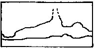
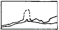
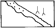
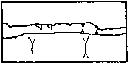
PLAN ELEVATION
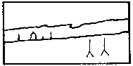
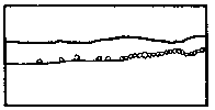
Continuation possible, difficult, impossible 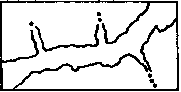
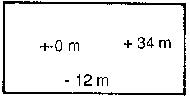
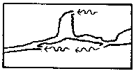
Height of a room (only for plans without elevations)
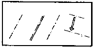
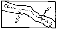
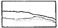
Passage in disturbed rock (tectonic cave) 
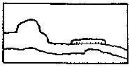
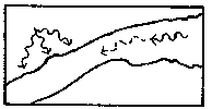
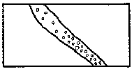
Anastamoses, Karren 
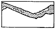
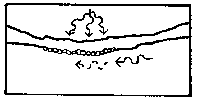
Cauliflower-calcite, Disc 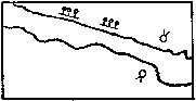
Bones 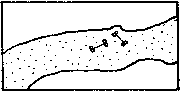
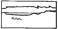
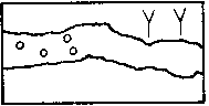
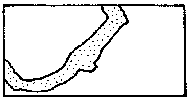
Clay (2nd version) 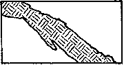
Compass Points is published quarterly in March, June, September and December. The Surveying Group is a Special Interest Group of the British Cave Research Association. By subscribing to Compass Points you will automatically become a member of the CSG and will receive its quarterly newssheet. The CSG's publishing agent is the Cave Radio & Electronics Group (CREG). CREG also publishes a quarterly technical journal to which you can subscribe if you want to. Subscriptions to Compass Points should be made payable to CREG, and sent to their secretary, David Gibson. Further details below. An information sheet about the CREG is available. Please send an SAE or Post Office International Reply Coupon.
NOTES FOR CONTRIBUTORS
Articles can be on paper, but the preferred format is ASCII text files with paragraph breaks. If articles are particularly technical (i.e. contain lots of sums) then Microsoft Word documents (up to version 7.0) are probably best. We should be able to cope with most common PC word processor formats. We are able to accept disks from other machines, but please check first. We can accept most common graphics formats, but vector graphic formats are much preferred to bit-mapped formats. Photographs should be prints, at actual size, and non-returnable (so we can cut them). Alternatively, well scanned photos (e.g. from a PhotoCD) supplied as .BMP or .PCX files are OK. It is the responsibility of contributing authors to clear copyright and acknowledgement matters for any material previously published elsewhere.
COMPASS POINTS EDITOR Wookey
734 Newmarket Road, CAMBRIDGE, CB5 8RS. Tel: 01223 504881
E-mail: wookey@aleph1.co.uk
SUBSCRIPTION & ENQUIRIES Andy Atkinson
c/o 38 Delvin Rd, Westbury-on-Trim, BRISTOL, BS10 5EJ
Email:a.m.atkinson@bristol.ac.uk
PUBLISHED BY
The CAVE SURVEYING GROUP of the BCRA.
OBJECTIVES OF THE GROUP
The group aims, by means of a regular Journal, other publications and meetings, to disseminate information about, and develop new techniques for, cave surveying.
BCRA ADMINISTRATOR
20 Woodland Avenue, Weston Zoyland, BRIDGWATER,
Somerset, TA7 0LQ
COPYRIGHT
Copyright (c) BCRA 1996. The BCRA owns the copyright in the layout of this publication. Copyright in the text, photographs and drawings resides with the authors unless otherwise stated. No material may be copied without the permission of the copyright owners. Opinions expressed in this magazine are those of the authors, and are not necessarily endorsed by the editor, nor by the BCRA.
ANNUAL SUBSCRIPTION RATES (amendments May 1996)
Publication U.K. Europe (air) & World:
World:surface Airmail
Compass Points 4.00 5.50 8.00
CREG Newssheet only 2.50 2.50 3.50
CREG Journal 8.50 10.00 12.50
Journal and Compass Points 10.00 12.00 15.00
These rates apply regardless of whether you are a member of the BCRA. Actual "membership" of the Group is only available to BCRA members, to whom it is free. You can join the BCRA for as little as £3.00 - details from BCRA administrator. Send subscriptions to the CREG secretary. Cheques should be drawn on a UK bank and payable to BCRA Cave Radio & Electronics Group. Eurocheques and International Girobank payments are acceptable. At your own risk you may send UK banknotes or US$ (add 20% to current exchange rate and check you don't have obsolete UK banknotes). Failing this your bank can "wire" direct to our bank or you can pay by credit card. In both these cases we have to pay a commission and would appreciate it if you could add extra to cover this.
DATA PROTECTION ACT (1984)
Exemption from registration under the Act is claimed under the provision for mailing lists (exemption 6). This requires that consent is obtained for storage of the data, and for each disclosure. Subscribers' names and addresses will be stored on computer and disclosed in an address list, available to subscribers. You must inform us if you do not consent to this.
COMPASS POINTS LOGO
courtesy of Doug Dotson, Speleotechnologies.
INTERNET PUBLICATION
Published issues are accessible on the Web at http://www.chaos.org.uk/CPIDX.HTM
THE CSG Web pages are at http://sat.dundee.ac.uk/~arb/CSG.html
Pete Grant
Wookey
Cave surveying in other publications
Bob Thrun, Ken Grimes, Andy Waddington, Olly Betts
· On Station book review
Wookey
· UIS proposed cave symbols draft
P Häuselmann & Y. Weidmann
Suggested cave symbols for discussion prior to the 1997 UIS conference.
This will be the CSG's inaugural field meet as a separate group. See the display ad on p4.
At the CREG AGM at the BCRA conference the CSG was officially floated as a separate SIG. CREG will continue to act as "publishing agent" for the time being and you can send you subs to either the CSG's new membership secretary, Andy Atkinson, or to Dave Gibson.
Interest in the group is increasing, as is our membership. Tell your mates, and sad surveying friends that they can come and indulge their addiction amongst like-minded people, and swell the membership even further.
For a copy of the CREG AGM Minutes, please send an SAE to Dave Gibson.
Subscription rates unchanged for time being, but will be revised next summer.
The BCRA Science Symposium is on 15th March this year. Anyone wishing to present a paper should contact Pete Cousins as soon as possible.
There are several vacancies on BCRA council at the moment. It was suggested that the SIGs ought to get together to choose someone to represent them on BCRA Council. It looks like this job might fall to Richard Rushton (meetings organiser for CREG), but if there is anyone else who also thinks they might like to get more involved with BCRA then please get in touch.
If you, or you Club want to join the cave surveying group, then please send remittance to the new keeper of the list, Andy Atkinson - address given in the Masthead.
· Cave Visualisation using VRML (Virtual Reality Markup Language)
· GPS use for entrance location on expedition.
Survex now has its own website: http://www.chaos.org.uk/survex/SVXHome.htm
Currently you can find some history of the project, the latest documentation (more up to date than the docs shipped with the software), and a page to download the latest releases for various OS's, as well as some related tools, such as Mike McCombe's Speleogen, featured in the last issue of CP.
Note that the 'Survex v0.70' release on the site is actually v0.69a at time of going to print, due to a cock-up. It will shortly be updated to the real McCoy.
Garry Petrie
I've produced an animation of a section of Lechuguilla cave, the FarEast, and posted it on my Lechuguilla photomap WWW page,
http://www.europa.com/~gp/lech.html
The animation was produced by exporting a three dimensional DXF file out of WinKarst and importing into a 3D animation program. The animation program allowed me to tilt the 3D representation of Lechuguilla on any axis and then spin it. The spin lasts for 10 seconds at a rate of 30 frames per second.
The software also allowed me to set light sources and define surface properties of the three dimensional faces exported from WinKarst. In the animation, the "bright" sides reflect the light source as the model turns. I had so much fun producing the animation, that I had to post the results now. You can download an AVI file for Windows users (use your media player) or MPEG file for cross platform viewing. WinKarst is under development for exporting three dimensional models of caves, watch for an update soon!
David Gibson has created a new usenet group for UK caving. This is news:uk.rec.caving
It is intended for discussion of all aspects of UK caving, including European caving where there is a UK connection - eg visits, expeditions etc.
MASHAM FIELD MEETING
Pete Grant
The joint field meeting with C.R.E.G held recently in North Yorkshire was extremely well organised at the superb TOC H centre in Cothersdale, Rosie's catering arrangements were as good as ever and everyone had an enjoyable if somewhat wet weekend due to the weather and the barrel of beer provided.
The field meeting was well attended by CREG members but only two of the Cave Surveying Group turned up, Ray Duffy and Myself.
The CREG members went off and did their own thing during the day which left us in peace to sort out the complexities of the Ease Gill System.
On the Saturday evening short presentations were given by various members on several subjects, Ray and Myself gave a talk on the problems surveyors have in fixing cave entrance locations and recording an accurate survey of the subsequent cave passages which went down very well.
We left our electronically minded colleagues with the small problem of how to fix two points a set distance apart and aligned exactly to Grid North ?. We are still waiting for a solution to this problem, any ideas???
The Groups next field meeting is planned for next March (see separate ad). This is to be the first field meeting run without CREG now that we have officially gone it alone so lets hope a few more surveyors can find the time to attend. It is planned to do some surface surveying using theodolites as well as some hands on underground surveying for those who wish to learn more of these techniques, there will also be the usual evening discussions and a chance to get your hands on the latest computer software.
There have been a number of articles relevant to surveying that have come my way this quarter.
Mapping Russell Cave with GPS and Induction Radio, by Gary O'Dell, Ron Householder & Frank S. Reid. GPS World, October 1996. This article describes how the team decided to use survey-grade GPS combined with induction radio to get accurate fixes on points in a normal compass & tape survey. They chose a really scrofulous cave full of mud, and mostly full of water to test the gear properly! First they surveyed the cave (it took two years as it is flooded for much of the year), then they marked approximate locations on the surface (just as a starting point), and took in induction radio gear, using the classic radiolocation techniques to mark several of the stations on the surface. Finally these points were accurately positioned using GPS, and cross checked using a theodolite survey, which was also taken into the entrance a short distance for cross checking the depth determination. They used earlier results showing that radiolocation can be used (at depths less than 30m) to position underground stations to the nearest 30cm horizontally, and 50cm vertically, to determine the accuracy of the underground survey. They found that the angular difference between the above & below ground surveys over a segment between radiolocation fixes was just over 1° (the worst section being 1°17' where the conditions were particularly grotty). The distance measurement was much better, giving an overall position error of about 1.5% from the nearest radiolocation, or 1.5% from the entrance for the uncorrected survey. The total clinometer error was only 0.09% by the end of the cave, making the clino readings much more accurate than the compass readings (surprise!). Thus the position of a point 30m from a control station is contained within an ovoid about 1m in diameter and about 15cm thick. The project showed that underground survey accuracy can be significantly improved by the use of radiolocation and GPS, at least on shallow caves (Russell cave is between 10 and 20m below the surface)
Laser et topographie souterraine, by Claude Wernert.(trans. Thomas Bitterli). Stalactite 46, 1996. This describes the 'vegatop', an aluminium box containing a 2mW distance measuring laser, a clino & a compass mounted on gimbals. You point the contraption and get distance (1-150m), declination and azimuth, in 1-10 seconds. The device is 25x15x7cm, and weighs 1.5kg, with a battery that will let you use it all day & take 400 legs. You can even use it to measure the heights of ceilings by bouncing the laser - this works from 5m for dark, icky surfaces, to 50m for damp, reflective surfaces. A major advantage in terms of accuracy is that the three instruments are joined together so they are always properly co-linear, although so far as I can tell you still have to read the clino & compass yourself.. The unit cost about 3500 Swiss francs, so it's not cheap, but it is quick and easy to use, to get a very accurate survey using tripods. This is probably the first realistic attempt at the holy grail of a widget that will do our surveying for us. Watch this space.
Derek Potter
Dear Sir,
I have read with interest the discussion about the
effect of magnetic objects, such as LED wires, batteries, karabiners
etc., on compass accuracy. It occurs to me that steel objects
are liable to quite strong permanent magnetisation. To obtain
a worst-case measurement of the safe distance, the object should
be magnetised first.
A recent discussion on BCRA survey Grades was sparked off by Bob Thrun noting an error in the BCRA3.SVX file supplied with survex, and querying the definition in the BCRA5.SVX file.
Here are some selected responses on the subject:
Bob Thrun wrote:
I looked at the Survex 0.70 distribution. There are two files that set the standard deviations for the measurements.
BCRA3.SVX says:
;BCRA Grade 3 specification file
;tape error
*SD tape 0.15 metres ;95% of readings are within 0.5m (3 S.D.)
;compass error
*SD compass 3.33 degrees ;95% of readings are within 10 degrees (3 S.D.)
;clino error
*SD clino 3.33 degrees ;95% of readings are within 10 degrees (3 S.D.)
;station position error
*SD position 0.15 metres
;95% of positions are within 0.1m (3 S.D.)
BCRA Survey Grade 3 is:
GRADE 3: A ROUGH MAGNETIC SURVEY. HORIZONTAL AND VERTICAL ANGLES MEASURED TO +/- 2.5 DEGREES, DISTANCES MEASURED TO +/- 50cm; STATION POSITION ERROR LESS THAN +/- 50cm.
How does the Survex file get from +/- 2.5 degrees to a standard deviation of 3.33 degrees?
[Wookey replies: ah, yes, well spotted. That's a mistake, caused by me forgetting to check the spec!. It should indeed read 0.83 degrees for compass & clino SD, and 0.17 for tape and position SD. Anyone using this feature in Survex v 0.70 should amend their BCRA3.SVX file.]
BCRA5.SVX says:
>;BCRA Grade 5 specification file
>;tape error
>*SD length 0.033 metres ;95% of readings are within 0.1m (3 S.D.)
>;compass error
>*SD bearing 0.33 degrees ;95% of readings are within 1 degree (3 S.D.)
>;clino error
>*SD gradient 0.33 degrees ;95% of readings are within 1 degree (3 S.D.)
>;station position error
>*SD position 0.033 metres
;95% of positions are within 0.1m (3 S.D.)
BCRA Survey Grade 5 is:
GRADE 5 A MAGNETIC SURVEY. HORIZONTAL AND VERTICAL ANGLES ACCURATE TO +/- 1 degree; DISTANCES ACCURATE TO +/- 10cm; STATION POSITION ERROR LESS THAN +/- 10cm.
Does +/- 1 degree wording really mean that 1 degree is the three sigma limit? I interpreted +/- 1 degree to imply a uniform distribution.
When I see a + or - figure on a mechanical drawing, I interpret it as a tolerance. No measurements are allowed outside the limits, but anything within the tolerance is acceptable. Others have interpreted 1 degree to be the one sigma limit, even though this implies that 32% of the readings are outside the limits.
Also, is the 0.33 degree standard deviation realistic? Has anyone, anywhere, ever gotten accuracy that good from a magnetic compass?
Fortunately, the actual value is not important. The ratios between surveys are what matters, and even that is pretty tolerant.
Bob Thrun
Ken Grimes says:
I think BCRA grades (and the equivalents in other countries) were devised as a simple guide to cavers, not intended for mathematicians.
I have always assumed that " +/- 1 degree etc." simply meant that you read the compass to the nearest degree, the tape to the nearest 10cm mark and held the end within 10cm of the point - and that was ALL it implied. Certainly that seems to be the implication in the ASF survey grades (see below).
Most cavers are NOT concerned about the details of the statistical accuracy, they just want a map that shows what the cave looks like. The important thing in a cave survey is to get the sketching of the details right (walls, floor features etc.). High levels of positional accuracy are only needed if you are drilling an access tunnel or looking for a possible connection between separate systems.
I don't have the official BCRA grade text handy, but for what it is worth the preamble to the ASF grading system (Australian Speleo. Federation, 1978) says the following:
"... Grades are assessed primarily on the basis of the instruments and methods employed ... This definition is further qualified by the degree of observational precision adopted in using the instruments. ... in most instances these values may be taken to mean simply the degree of fineness of each individual reading, e.g. if a compass is read to the nearest whole degree the observation precision is assumed to be 1 degree. ... expected accuracies, ... are intended only as a rough indication of the overall accuracy of the whole survey."
A footnote adds that "In deriving expected accuracies, a tendency towards pessimism was adopted, mainly to allow for the poor observing conditions ... etc."
The ASF Grade 5 (which approximated BCRA 5) is defined as:
"Compass & tape traverse. Directions by calibrated compass (e.g. liquid damped prismatic or semi-supported Brunton). Vertical angles by calibrated abney level or similar clinometer. Distances by metallic or fibreglass tape or tacheometry." It gives the observational precisions as 1 degree (NB, NO +/-) and 5cm and the "expected accuracy" as 2%.
If the computer programs are capable of doing statistical analysis of the apparent accuracy, that is fine, but I see little point in trying to tie the results back to the "BCRA Grade" guidelines. It would seem better to quote the actual statistical results and leave the BCRA grade as a general guide.
Ken Grimes
Andy Waddington:
Bob is quite right about the definitions of BCRA grades being tolerances rather than three-sigma limits. However, it is not realistic to actually treat them the way they were defined, when doing statistics etc.
When CRG grades (of which BCRA grades are a refinement) were invented, they were defined to give people an idea of the way the survey was done, rather than created as suitable error estimators for doing statistical analysis.
Thus the inventors were actually specifying which ticks on the compass/clino you were reading. If you were reading whole degree ticks, then the actual value could be anywhere in a rectangular distribution from -0.5 to +0.5 degrees from the figure written down.
Now this assumes that the only error is rounding error. You can see that to get a true rectangular distribution, you would actually have to be reading bearings near the half-degree to extreme precision to get the correct whole degree. Real surveying doesn't happen like this - which is just as well, given that all the loop closure and blunder detection algorithms we use are based on 'standard' statistics, which assume that each individual error arises from a normal distribution.
What we probably have is a distribution which is a convolution of a normally distributed random reading error and a rectangularly distributed rounding error. The random error's standard deviation varies with circumstances (e.g. it will be bigger for compass readings on legs way off horizontal when done with a Suunto). The rounding error's distribution is theoretically constant.
In practice, we assume for simplicity that the random error is the same at all bearings and inclinations. Strictly, the BCRA grades don't give any clue as to how severe these are.
Also in practice, the rounding error is not constant. If you look at an 'average' survey, you will find that most bearings are whole degrees, but a small proportion are to half a degree. What is happening is something like this: If a bearing is clearly not close to the half-degree tick, then it is given to the nearest whole degree, just like the grade says. However, if it is close to the half degree, then that is what gets written down. So we might be getting 80% of the bearings given a whole degree, with a +/- 0.4 degree tolerance, and 20% given to the half degree with a +/- 0.1 degree tolerance. I don't know anyone who has even bothered to think about the implications of this for survey error statistics (if indeed there are any to a level which matters).
So, assuming for the moment that rounding error really is constant, what Survex should be doing, is putting in an estimate of the standard error of a reading, which assumes a normal distribution which gives the 'best fit' to the actual error distribution which is the convolution referred to above.
This will actually be flatter-topped and steeper-sided than the normal distribution that Survex (and all the other survey programs) are actually assuming.
Luckily, statistics are forgiving in the long run, in that the more errors you are dealing with at once, the more closely the resultant errors are to being normally distributed, whatever the shape of the original error curve.
For the most part, Bob is quite right, in that we don't care all that much about the absolute values of the standard deviations of the error distributions of the various survey grades - it is only the ratio between them that we need to worry about in loop closure, though perhaps real values are needed for good blunder detection.
However, if your survey contains sections surveyed by different methods, for example some compass/clino/tape, some theodolite/tape and some radio location work, then the 'real' values do become important. If you have an estimate of the errors of a radio-location done by taking a series of locations at random in a grid, this will give you a 'realistic' estimate of the standard deviation of the errors. If you use values from the BCRA grades for the errors of a tape/compass/clino survey, and these are 'wrong' by some factor because the shape of the distribution is not 'correct', then you will incorrectly estimate the ratio of the errors between radiolocation and magnetic survey, causing you to put undue reliance on one or the other.
The correct answer, of course, is to go out and design practical experiments to estimate the errors on readings taken to "BCRA grade N" whatever "N" is.
This avoids placing great reliance on a lot of theory which may be overlooking something, and will probably prove to be quite an eye-opener. At least it would give much more useful values to put into programs like Survex, and avoid the pitfalls of erroneous errors in mixed-method surveys.
Andy
Olly Betts says:
Bob: 'Does the +/- 1 degree wording in the BCRA definition really mean that 1 degree is the three sigma limit?']
That's one interpretation, another being that the tolerances given are 1 standard deviation. As Waddington suggests, it's likely that the thinking behind them is that the random error is simply the 'quantization' error in making the reading to the nearest degree or whatever. However, that's too simplistic in my view.
Bob: I interpreted +/- 1 degree to imply a uniform distribution. When I see a + or - figure on a mechanical drawing, I interpret it as a tolerance. No measurements are allowed outside the limits, but anything within the tolerance is acceptable.
This is fine for engineering drawings. As a pass/fail criterion for your data being BCRA grade 5 or not, it's fine in theory, but impossible to verify in reality.
It is sometimes possible to determine if there's a larger than allowed error in your data, but in most cases, a compass reading of 1.1 degrees off will not be detectable. So we can sometimes detect that data isn't of the desired grade, but usually we can't. I'm talking about random errors here, not gross errors/blunders.
You'd have to go down the cave and resurvey all the stations to a much higher accuracy in order to know for sure that all your readings were to the required accuracy, which rather defeats the point.
If you take the uniform distribution interpretation, its standard deviation is: tolerance/3. So what we can do is to 'convert' the BCRA criteria into something we can handle more easily statistically, and then use this. What we do is to 'pretend' the uniform distribution is a Normal distribution with the same mean and standard deviation.
There's a theorem is statistics called the Central Limit Theorem. Put simply in terms which I hope are understandable to most, what this tells us here is that even though the error in each reading may not have a Normal distribution (that's the 'bell curve' distribution), as we add more and more of them together, the distribution of the sum tends towards a Normal distribution.
A quick illustration to show this in action:
A 6 sided die has a uniform distribution on the numbers1 to 6:
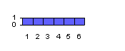
Roll 2 such dice and sum, and the distribution is:
Roll 3 and add to give (totals scaled so max. is 10 stars):
Which already looks remarkably like a Normal distribution.
So the Central Limit Theorem tells us that it's reasonable to pretend our errors are Normal, even if they aren't really. Now we can sum errors along traverses and around loops and so on, and apply confidence tests on the loop misclosures to tell us whether the data is up to our interpretation of the claimed BCRA grade.
Incidentally, the Central Limit Theorem explains why the Normal distribution crops up so often in the real world. The point is that many things you might measure depend additively on a number of underlying factors. Whatever the distribution of these underlying factors, their combined effect is a Normal distribution.
Bob: Fortunately, the actual value is not important. The ratios between surveys are what matters, and even that is pretty tolerant.
This is true for the loop closure stuff. However, you do need actual values for the confidence tests. I guess this point is something the BCRA Cave Surveying should sort out.
Olly
and Bob completes the discussion:
My interpretation of the nature of error distributions of the BCRA grades was based more on the wording of the definitions than it was on the way that the errors were caused. By 'uniform distribution' I mean that the probability is the same within the limits and zero outside them. I think that is the mathematically correct term. If you plotted the distribution, it would be a rectangle or one pulse of a square wave. Andy Waddington was correct in saying that we would get a uniform distribution if the only error were rounding to the nearest degree. If rounding was the dominant error, we would get a flat-topped distribution with sloping sides. Depending on how the steep the sloping sides are and the width of the distribution, the standard deviation might be the same as a uniform distribution.
Andy: Luckily, statistics are forgiving in the long run,….
The long run may be rather short in statistics. It does not take very many errors in combination to approximate a normal distribution. I was going to give the example using dice, but Olly beat me to it - and did it better too.
Andy: The correct answer, of course, is to go out and design practical experiments to estimate the errors on readings taken to "BCRA grade N" whatever "N" is.
I have some old data that I am working up right now, but I'm not ready to publish just yet. I need to consult with a statistician in order to separate people effects from instrument effects. Seriously, if someone knows how to separate effects using data that have already been collected, please send me a mail/Email.
Several of the cave survey programs report error statistics, but they work in a network, make simplifying assumptions, and emphasise short loops. I'll describe a study that I've wanted to do, but is far down on my to-do list. Anyone else is welcome to do it. I'd like to see the results.
Generate random walks through survey data to make loops of various sizes. Assume accuracies for compass, clinometer, tape, and position error. Add the error ellipsoids of each shot to get an error ellipsoid for the entire loop. Compare the closure error with the error ellipsoid. Repeat this for many loops. Repeat for different assumptions about accuracies.
I thought I knew how to add ellipsoids, but now I am not so sure. I see references to the 'pedal curve' in some survey literature. Anyone know about this?
From Ken Grimes' description, the Australian grades are more loosely worded. They resemble the older CRG grades. The BCRA deliberately tightened up on the language used in its grade definitions. That, plus the discussion of accuracy vs. precision, and the need for calibration, makes me think that the BCRA grades mean exactly what they say.
A computer program has to assign some sort of weights for a closure adjustment. We'd like to use the correct values. Also, I'd like to have an answer to the question "How accurate is the map?" If we ever get to the point that we can give a quantitative answer, the answer will probably be too complicated for the questioner.
All of our normal surveys are essentially the same grade. They are all compass, tape, and clinometer surveys. The BCRA accuracy estimates are overly optimistic. The only surveys that are a different grade are underwater surveys, compass and tape (no clino) surveys, compass and pace surveys, and a very few theodolite surveys. To a caver making his way through a cave, detail and completeness are more important than baseline accuracy. Denis Warburton pointed this out 30 years ago.
Anybody have a way for grading detail and completeness?
Bob Thrun bob.thrun@wdn.com
It is intended at this field meeting to try and fix the locations of entrances connected to the Three Counties System on Leck Fell or in the Kingsdale valley using theodolites, plotting these surveys using Survex on return to the farm in the evening and discussing any abnormalities with the current maps and guide books. There will also be the chance to do some underground surveying and a workshop to show both beginners and experienced members the best way to eliminate errors in surveying which only really come to light when you have multiple entrances and many small and large loop closures.
The accommodation will be at Bull Pot Farm on Casterton Fell in North Yorkshire. This is the club hut of the Red Rose Cave & Pothole Club and is ideally situated for exploring the Three Counties System, (the nearest entrance is virtually in their back garden). It is Standard hostel accommodation with alpine style bunks and a self catering kitchen although there are many excellent pubs providing food in the area. The club has a well stocked beer cellar and the late night revelries are second to none!!. Cost is £2.50 per person per night, i.e. £5 for the weekend.
Novice surveyors are particularly welcome on this meet, with a surveying workshop giving the basic techniques, and some practice and useful tips from the more experienced members. There will also be the opportunity to try out the available range of surveying software, and see some ideas currently under development, and finally a discussion on methods of marking survey stations underground.
Wookey
A few issues a go Bill Mixon reviewed George Dasher's comprehensive tome on cave surveying, 'On Station' in a rather uncomplimentary manner. He particularly didn't like the grammatical errors in the book. I have since read it, and have to say that I did not really notice the reported problems, but thought that the content of the book was excellent. It gives a comprehensive discourse on surveying, and despite that American basis, it covers nearly every technique I have ever come across.
Upon opening the book, you are greeted (on the front and back inside covers) by all the NSS cave surveying symbols along on a very long passage - a nice touch. Inside are:
Section 1: Collecting the data:
The basics, instruments, sketching equipment, the Tape Person, Book Person & Instrument Person, Leadership, Tricks of the trade, Project caves, Surface location.
Section 2: Managing the data:
Data reduction & plotting, Survey error and loop closure, Computers.
Section3: Drafting the Map
Drawing equipment, Drawing the working map, Drawing the final map, The components of the final map.
Appendices:
NSS symbols, AMCS (Mexican) symbols, MSS (Missouri) symbols, USGS Map symbols, A survey program, BCRA grades, Glossary, Bibliography, Sample maps.
This is a pretty thorough piece of work! George goes through all the possible instruments - steel tape, fibreglass tape, tape with no reel, Topofil, electronic devices, Suuntos, Bruntons, Sistecos, Levels, transits, theodolites, even plane tables & Alidades are mentioned (I had never heard of the last two!). All these are compared for cost, ease of use, portability, etc., and well-judged comments are made. Throughout the book it is clear that George Dasher has an enormous amount of experience as he describes every conceivable technique fairly and thoroughly.
Useful tips are sprinkled through the text, especially in the 'Jobs' section describing what the members of the survey team should do, and how they should do it. This section is completed by some tips on managing large projects and handy info like how to get a ceiling height where the ceiling cannot be reached. The locating caves section is specific to US topo maps.
Section 2 describes the maths of data reduction including sequential and simultaneous loop closures, and the increasing power of computers is discussed. Obviously a book like this can only be a snapshot of the time when it was written, and George does a reasonable job of generalising so it won't go out of date too fast.
Section 3 describes the techniques for showing multiple levels, extended elevations, getting a surface profile from a map, advice on scale, layout etc. It goes on to detail the techniques for final map production. This is the only area where I noticed a significant omission. Despite describing 6 letting techniques (Kroy machine, stencils, transfers, stick-on letters, typesetting & Leroy set) he doesn't mention the popular 'magic-tape & laser printed labels' method.
After reading this little lot it is a pleasure to look through the excellent examples at the end of the book of a selection of drawn-up surveys showing a range of techniques. Most of these are short caves, and one gets the feeling that the book is a little biased to the typical American short, horizontal cave where the floor can be drawn in loving detail and everything fits on a sensible sized piece of paper. There is little discussion of what to do if you have a huge system requiring either tiny scale or impossibly large piece of paper. Nevertheless, despite these small criticisms, this is a beautiful book full of useful information, which does a good job of not being so US-biased as to be no use in other areas. I would recommend it as a read for keen surveyors and beginners alike. Get a copy for the club library. Pretty good value for £19.
Ph. Häuselmann and Y. Weidmann, Translation: N. Ruder, Wookey
Here are a proposed set of UIS-standard cave survey symbols. BCRA council have met and decided that UK input should be from the Cave Surveying Group via Terry Whitaker at Greenfoot Barn, Greenfoot, Bentham, Lancaster, LA2 7EQ, Tel:015242 62269.
This needs to be completed by New year at the latest so it can be passed on to U.I.S. for inclusion in their international discussion on this topic. If you have any comments about the presented symbols - good or bad then make them known to someone in the CSG as soon as possible.
[Ed.: I am generally happy with this symbol set. I don't see anything I couldn't live with, except for the pitch/climb/aven letters, which I think are really too confusing given existing U.K usage.]
On the occasion of the 10th National Congress of the Swiss Cavers Association in Breitenbach the Second International Topography Meeting was held to discuss and unify the different types of symbols used in cave topography. In spite of (or maybe because of?) a quite low participation we are now able to present a new symbol list. This list is meant to lead to reflection and discussion on the subject. At the International Congress UIS 1997 in La-Chaux-de-Fonds (Switzerland) a revised version will be worked out, taking into account feedback and additional information. The final version will be published shortly after the UIS congress.
The list including additional explanations can be obtained in German, French, Italian and English from Ph. Häuselmann or Y. Weidmann.
One may ask why somebody cares to change and redraw the current symbols. There is already an official symbol list, isn't there? Wrong! Experiences of several frustrated topographers have shown significant difficulties in understanding and interpreting similar or identical symbols. This not only happens to topographers from different countries, but also to cavers working on the same cave system (great confusion occurred even among people working on the "Sieben Hengste-Hogant" region which isn't exactly neglected)! In other countries, symbol conventions change anyway. This is why during the First International Meeting on Underground Topography in Charmey (1991) the idea to give the work on an international understanding on cave symbols another go was widely appreciated. We are now able to present our first results.
This list is meant to be an international basis of understanding on which the different countries, if necessary, can build their own extra lists.
In order to keep some consistency between the old and the new list, and based on the idea that several special symbols may be most useful, there is a final section referred to as "additions" (found on the front cover). These symbols couldn't be put on the main list due to their limited or strictly regional occurrence. Despite this we would like to insist on the fact that these symbols represent a sensible and often very useful additional help to clarify the map.
Today's active cave surveyors all know that the map with figures and symbols only makes out half of the work of a good cave explorer. The other equally important part consists of the description of the cave including all the facts and assumptions that cannot be shown on the map. Observations on geology, sedimentology, hydrology, climate, flora and fauna, a historical summary of the exploration, a list of special equipment needed or already in-situ and so on, should be part of a good cave description and are not to be neglected. Guesses on continuations and maybe some thoughts about cave genesis complete the description, which gives a reliable basis for further work.
It seemed sensible to give some explanations for the different symbols in order to make our reasoning and ideas clearer to the reader.
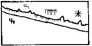
Main survey points: The main survey points have been kept in the list, but often they are no longer shown on fair copies. This also applies to:
Subordinate survey points: The old symbol, a round dot, has been abandoned because it could be confused with the symbols for stalagmites and gravel / sand. The new symbol, the empty triangle, should be understood by everyone.
Outline of a passage: as before
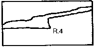
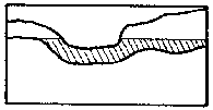
Underlying passages: As an additional aid to distinguish the lower from the upper passage one can stop the line of the lower one shortly before it crosses the upper one. This is shown in the elevation.
Too narrow continuation: as before
Continuation possible: as before
Presumed dimensions of space: as before
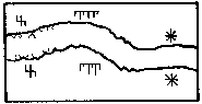
Ceiling form: The symbol for the form of the ceiling of a cave can be useful for those cavers who do not draw elevations, but as an extended elevation is highly recommended (see also documentation on the 9. National Congress 1991, Charmey) this symbol should not be used very often.
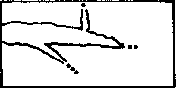
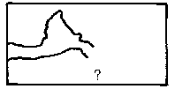
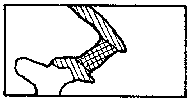
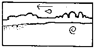
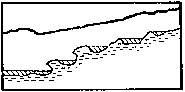
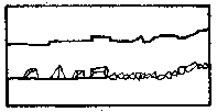
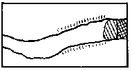
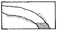
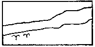
Cuesta scarp line: The cuesta scarp line can give valuable information especially for smaller caves and overhangs. It describes the actual entrance to a cave including the upper ceiling region and should therefore not be omitted. At the scarp line the cave begins.
Cross-section: Cross-sections are of major importance for the understanding of a passage. For each passage cross-sections must be drawn. The arrows indicating the direction of view are done differently, a clear indication is, however, necessary.
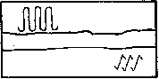
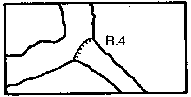
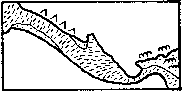
Steps/Drops: This symbol is well known, just don't forget that the little dashes are always to be orientated downwards!
Pitches: The filled or empty triangle has been replaced by dashed lines for two reasons: First, the dashed line is easier to draw, secondly it is unclear even to most draughtsmen whether the empty triangles represent the smaller or the higher steps or when they should be filled (at 5 m or 10 m?).
Avens, Aven-Pitches: The plus and minus signs can be written inside or outside the cave. For reasons of clearness they should be encircled when written outside the cave.
The symbols:
P. for a pitch (needs gear)
R. for a climbable drop
C. for an aven (needs gear)
E. for a climbable aven
are now internationally understood and are also shown here.
[Ed: The above is clearly a problem for those in the UK, as the change in definition of C is confusing to say the least - can anyone think of a way out of this language problem - are symbols feasible?]
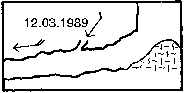
Contours: Isohypses (lines of same altitude) with altitude measurement as shown on geographic maps are seldom used, as the exact ground level is not always easily established and precise drawings can cause serious problems. Gradient lines are used more frequently.
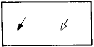
Gradient arrows: for reasons of consistency with older symbol lists the differentiation between gradient arrows inside and outside the cave have not been changed. The difference should still be clear from the drawing itself!
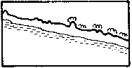
Gradient lines: Gradient lines are the most common methods to illustrate the ground structure. As on geographic maps narrow spacing indicates a steep and wide spacing a slow slope, but the height differences are not absolute.
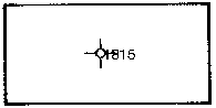
Altitude above sea-level: This symbol has also been kept for reasons of consistency and designates the altitude above sea level used in the map. It is highly recommended to write 1880 m. instead of just writing 1880. Generally maps are all to be done in SI units.
Difference in elevation in relation to the entrance: as before
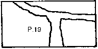
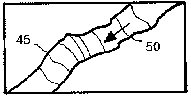
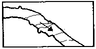
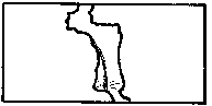
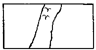
Joint, fault, bedding plane: These symbols can be quite important for understanding the cave. It is recommended not to use these symbols unless one is totally sure about their nature. The arrow connecting two joint symbols is normally only used in the plan. It shows whether a cave crosses a joint several times or whether it follows the joint itself.
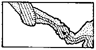
Lake, flowing water: as before. It is recommended not to draw the hatching at right or 45 degree angles because it might interfere with other symbols and because it doesn't look nice.
Sump: as before
Waterfall: Two versions are presented in the plan. The left one is connected with the symbol for a step/drop and is therefore preferable.
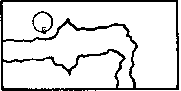
Spring/Inlet, sink: Springs or sinks which flow sideways in or out of a cave don't need a half circle to be characterised, whereas water inlets and outlets in the ground should be marked with a half-circle to distinguish them clearly from normal flowing water.
Widespread water inlet: An old and very confusing symbol which was also used for drainage water has been omitted and replaced by three normal water arrows with joined ends.
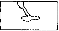
Seeping of a water course in a sediment: Unlike the waterhole the half-circle is omitted as the seeping usually takes place over some distance. Instead a dashed arrow is connected to the full arrow to make things clearer.
Symbols for temporary waters of all kinds have been omitted altogether for the following reasons: Hydrologically many water courses are also dry in dry times and are therefore also temporary. Added to that, there have been many different symbols in the old symbol lists that would severely extend this list. One may add a note on temporary waters to the cave description.
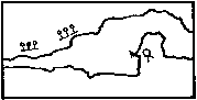
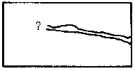
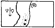
Scallops: Even for geomorphologists it is sometimes difficult to work out in which direction the water used to flow, so all we suggest is to add an arrow, representing the old flow direction, to the known symbol.
Driphole: For reasons of consistency this symbol has been kept for holes made by dripping water in sediment.
Flute: The differentiation between erosional and corrosional flutes has been omitted, because, especially with flutes on lateral walls, they cannot always be identified correctly.
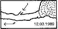
Draught: This is a well known symbol. It should always include the date of measurement. Three feathers (not drawn) stand for a very strong draught.
Ice / snow / firn: The old star symbol used for snow hasn't been satisfactory for quite some time as it is very time consuming to draw and the ground structure cannot be shown. Added to this, it can easily be mistaken for the crystal symbol. The old symbol for ice is confusingly similar to true gradient lines.
Taking all this into consideration we agreed on the following solution: Snow is transformed to firn and subsequently to ice. By morphology and composition all three substances are the same, therefore it should be represented by the same symbol. The one that has been chosen is easy to draw, shows the ground structure and cannot be mixed up.
Stalagmites: as before
Stalactites: as before
Calcite curtains: The presented solution is not easily understood at first sight but seems to be the best (alternatively you draw the curtains into your map).
Calcite columns: as before
Helictites: This symbol is as eccentric as the formation itself and is therefore easily understood.
Straws: This symbol doesn't need any further explanation.
Crystals: For reasons of international understanding the letters identifying the minerals should be avoided, first because correct mineral identification is often not as easy as it may seem, and second because a C for calcite is an K in German and a # in Chinese.
In general we do not recommend the use of letters as symbols on the actual map. The resulting Babylonic confusion can be lethal for understanding.
Gour pools: as before
Floor calcite: Often this or a similar symbol is also used for clay (see there).
Wall calcite/ calcite in general: as before
Moonmilk: To avoid mistaking this symbol for the guano symbol an additional bow has been added to the usual m.
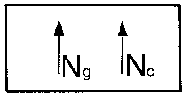
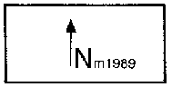
North: On several maps information on declination is missing or is incomplete which makes the calculation of geographic north almost impossible. Beside the normal North arrow one must specify whether one relates to geographic, magnetic, or cartographers north. If one is relating to magnetic north the date of measurement must be mentioned.
Blocks / debris: as before. The size can be modelled on the reality.
Stones/ pebbles: as before. The size can be modelled on the reality.
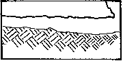
Clastic sediments: Sand, silt, clay and humus: With the exception of humus this group is a sediment whose grain size and therefore names depend on the velocity of current of the carrying water. In flowing water sand is deposited whereas in standing water clay is deposited. In contrast to this the floor calcite (see there), which is a chemical precipitation, does not represent the velocity of flow but the chemical equilibrium.
As floor calcite occurs quite frequently a special symbol needed to be found. The small parallel dashes did a good job as they also showed the ground structure.
Unfortunately several topographers characterised clay by a series of small dashes, which can lead to some confusion. For these reasons, a geologically correct solution has been worked out. For those who absolutely don't want to abandon the dashes there is an alternative symbol for clay on page 6.
Clay covered walls: This symbol can also be used to show stagnation zones.
Guano: as before
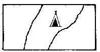
Camp: as before
Continuation: An indication on the effort needed for further exploration is particularly recommended for bigger cave systems where complete descriptions have not yet been done. A single dot stands for easy continuation, two dots stand for continuation with a certain effort (digging, blowing-up....), three dots stand for an (almost) impossible continuation.
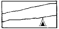
Height of a passage / chamber: An indication of height can be useful for a caver who doesn't draw elevations. But since this is highly recommended (see documentation of the 9. National Congress 1991, Charmey) this symbol is not going to be used very often.
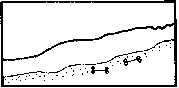
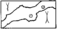
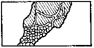
Passage in disturbed rock: This symbol means that a cave lies in highly disturbed / mechanically deformed rock. It should be used for caves lying in natural inhomogenous blocks of rock.
Anastomoses / Karren: as before
Cauliflower-calcite / discs: These two symbols for sinter are of a regional importance and can be quite useful.
Bones: This symbol does not need any further explanation
Clay, 2nd version: see also clastic sediments (in the main list)
PLAN ELEVATION
Main survey points (fixed),
Subordinate survey points (marked)

Outline of a passage
Underlying passages
Too narrow continuation
Continuation possible
Presumed dimensions of space
Ceiling form (only for plans
with no elevation)

Cuesta scarp line, Cross-section
(arow in line of view)
Step
Pitch (depth in metres)
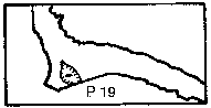
Pitch opening to the surface
Aven, Aven/pitch
Contours (altitude a.s.l), Gradient
arrow in- and outside of the cave
Gradient lines,
altitude above sea level
Difference in elevation, Joint,
Fault, Bedding plane,
The arrow is on the same fault
Flowing water, lake
Sump
Waterfall (2 versions)
Inlet/Spring, Sink
Widespread water inlet, seeping
of a water course in a sediment
Scallops, driphole, flutes in general
Air draught strong, light, Ice/Snow/firn
Stalagmites
Stalactites
Calcite curtains, Columns
Helictites, Straws, crystals
Gour pools
Floor calcite, Wall calcite,
Moonmilk
Geographic north, Cartesian north,
Magnetic north (with date)
Blocks /debris
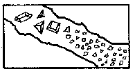
Stones/Pebbles
Clastic sediments:
Sand/silt/clay/humus
Clay covered walls
Guano
Camp
 Bibliography:
Dériaz P. (1991): Compte-rendu de la Rencontre Internationale de Topographie. - Actes du 9e Congrès National de la SSS, Charmey 1991.
Fabre et al. (1978): Signes spéléologiques conventionnels. - UIS / AFK.
Müller R. (1980): Signaturen für Höhlenpläne. - Beiträge zur Höhlen- und Karstkunde in Südwestdeutschland, 22, 1980.
Grossenbacher Y. (1992): Höhlenvermessung. -
SGH-Kurs Nr. 4
Address of authors:
Ph. Häuselmann, Haldenstrasse 32, 3014 Bern. Tel: +41 31 3320174 mailto:praezis@mpi.unibe.ch
Y. Weidmann, Steinstrasse 72, 8003 Zürich. Tel: +41 1 4636179 mailto:weidmann@eawag.ch